 Some
50 km west of the Uluru the second, intriguing natural feature of the National
Park can be found, the Olgas or Kata Tjuta, a group of 36 island
mountains, which are separated by magnificent gorges. The domed mountains
cover an area of 21.68 km² and are composed of a coarse grained conglomerate
of granite, gneiss and other volcanic rock. Some
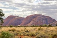
50 km west of the Uluru the second, intriguing natural feature of the National
Park can be found, the Olgas or Kata Tjuta, a group of 36 island
mountains, which are separated by magnificent gorges. The domed mountains
cover an area of 21.68 km² and are composed of a coarse grained conglomerate
of granite, gneiss and other volcanic rock.
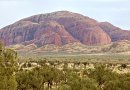
Kata Tjuta in the language of the Aborigines means "many heads". The
highest point is Mount Olga, which rises approximately 546 m above the
surrounding plain, 203 m higher than Uluru! Many Aboriginal Dreamtime legends
are associated with this place, and the great snake Wanambi is said
to live on the summit of Mount Olga and only comes down during the dry
season.
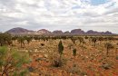
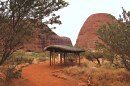
On your way to these mountains you should stop at the Dunes Viewing
Area, which offers a spactacular view of the Kata Tjuta. There are two
major walks leading into the mountains: one to the Valley of Winds, which
takes about 4 to 5 hours for the journey there and back and is a bit strenuous,
and another to the Olga Gorge,
which takes just an hour. Both offer a geat variety of amazing views and
reveal a surprising variety of vegetation. |
 |
